Travel News - Queensland
28 May, 2005 - 31 May, 2005 - Burleigh Heads - Brisbane - Noosa Heads
|
A short drive from Byron Bay is the border to Queensland. This is a good destination during winter because it is warmer than the southern states in Australia. We are heading for the warmest part of Queensland at the tip of Cape York. But before we get there we have some 2000 km of Queensland coastline to follow. It started just over the NSW/Queensland border on the sunshine coast at Burleigh Heads. It is much better known as Surfer's Paradise, but we stayed about 10 km south of Surfer's Paradise in Burleigh Heads. The main purpose of stopping a couple days on the Sunshine Coast was to visit my Uncle and Aunty, Kent and Lorraine. We had a wonderful afternoon and dinner at their house. Thanks for a wonderful afternoon Kent and Lorraine. |
Mit dem Verlassen von Byron Bay verlassen wir auch New South Wales. Willkommen in Queensland! Die Wintertage sind doch relativ kühl - man muss einen Pullover anziehen -, da freuen wir uns auf die Wärme hier. Wir bleiben ein paar Tage in Burleigh Heads ein paar Kilometer südlich von Surfers Paradise. Der Ort heisst nur so, die Wellen sind auf vielen anderen Stränden viel besser als dort. Surfers Paradise ist eigentlich ein Schock - es erinnert mich an Italien. Die Hochhäuser - das höchste soll um die 70 Stockwerke haben - stehen mehr oder weniger am Strand. Man muss sich sputen um Sonne am Strand zu bekommen. Vielen Dank an Kent und Lorraine, Karls Onkel und Tante, die uns mit einem leckeren Abendessen verwöhnt haben. |
|
After our short stop on the sunshine coast we headed north through Brisbane to Noosa Heads. Noosa Heads is a tourist town with low rise resort development, so it is quite a relaxing place to stay. There are some nice beaches in the area and the small towns with their restaurants and cafés are usually not far away. Our next destination was not really defined from here. We just knew we were heading north up the coast. On the morning we left the caravan park we spoke to another traveller next to us. He gave us the idea to drive up the beach to Fraser Island. We intended to visit Fraser Island, but were not sure if we should leave it until later. But the suggestion to drive 55 km along the beach through the Great Sandy National Park appealed to us. |
Jeder Küstenabschnitt hat einen anderen Namen von sunshine coast zu gold coast und coral coast. Wir stoppen kurz in Brisbane für einen Kaffee und fahren weiter nach Noosa Heads. Brisbane, die Hauptstadt von Queensland können wir uns auf dem Rückweg ansehen. Noosa Heads - keine Hochhäuser am Strand - liegt an einem Fluss der in das Meer mäandert. Ob im Grünen beim Fluss oder an einen von den vielen Stränden am Meer, es ist für jeden etwas dabei. Man kann wirklich sagen, dass wir in den Tag hineinleben. Auf Fraser Island zu gehen haben wir erst am Tag unserer Abreise in Noosa überlegt und beschlossen. Ein Zeltnachbar hat uns auf die Idee gebracht die Fähre auf dem südlichen Spitz der Insel zu nehmen. |
|
The drive along the beach was really 55 km. I was concentrated on the driving, because beach driving can offer some nasty surprises if you are not awake. Regina took the time to take some photos and take in the passing sand formations, so I knew what we had seen along the drive. Regina and I both find beach driving quite tense. Sand driving is OK, but when you have the influence of rising tides the whole situation changes. Even though we haven't been bogged yet, we don't want to have the first experience with a rising tide. |
Die Fähre liegt am Ende von einer 55 km langen Fahrt dem Strand entlang. Beim Fahren am Strand muss man sich an die Gezeiten halten. In diesem Fall wird geraten 2-3 Stunden vor/nach Ebbe zu fahren um nicht zu riskieren, das Auto im Meer zu verlieren. Es kommt immer wieder vor, dass Leute die Gezeiten unterschätzen. Man braucht schon gute Nerven, vor allem, wenn der Strand nicht wo weit wie auf dem Foto ist sondern enger und dann natürlich ins Meer abfällt von wo die Wellen alle paar Minuten dem Auto nahe kommen. |
01 June, 2005 - 04 June, 2005 - Fraser Island - Hervey Bay
|
At the end of the 55 km drive along the beach we caught a barge across to Hook Point, the southern tip of Fraser Island. Fraser Island is the world's biggest sand island. That's about 130 km long and 35 km wide and it's just sand. And it is all sand. The only vehicles on the island are 4WD, because to roads are also sand. |
Die Fähre legt einfach am Sandstrand an. Fraser island besteht nur aus Sand und was darauf wächst und lebt oder gebaut wurde. Es ist einfach faszinierend auf eine 130 km lange und 35 km breite Sandinsel zu fahren. Ohne 4WD ist da nichts zu machen. Die Fähre dauert nur 5 Minuten und dann beginnt der Spass. |
|
Fraser Island is a fascinating place with beautiful rainforest and perched lakes high in the sand hills. We camped for 3 nights on Fraser Island and had lots of rain. At the end of it we had sand through everything - the tent, the cooking stoves and between our toes. But hey, the best time to see a rainforest is in the rain. Because of the rain we looked around in the south part of the island driving through the forests and visiting the lakes. |
Bis zum Zeltplatz haben wir noch etwa 30 Kilometer zu fahren - kein Problem, oder doch? Man bedenke die Sandstrassen, so ein paar Kilometer können dann schon in 1 bis 2 Stunden Fahrt ausarten. Die Kombination von Reisegeschwindigkeit und Ebbe Zeiten regieren die Tagesplanung. Es gibt ein paar Strassen im Landesinneren, an manchen Stellen muss man jedoch am Strand entlang fahren um zum nächsten Platz zu kommen. Natürlich gibt es auch am Strand Schiffwracks und mehr zu sehen. |
|
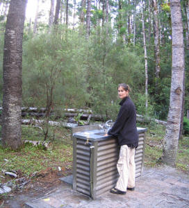
Everything was so green and huge. On the trees we huge parasite ferns which were amazing. We did a walk through one of the central rainforests which followed a creek bed. There was just white sand on the bottom of the creek bed. The water was so clear you could not see the water in the creek. The only giveaway was the reflection and the occasional ripple in the water. The camping area on Fraser Island are quite well set up. They have had problems with the dingo and human interactions in the last few years, so all the camping areas are within a fenced enclosure. Keeps the dingoes out and the humans in ! The other thing I really liked was the kitchen sink in a bush setting. Highly impractical for the home, but great for camping. Saves you having to take your own kitchen sink. |
Unser Zeltplatz - wir waren die einzigen - war eingezäunt als Schutz vor den Dingos. Fraser Island ist einer der wenigen Plätze wo Dingos reinrassig sind und sich nicht mit Hunden gekreuzt haben. Dingos sind nicht grundsätzlich gefährlich. Sie sind wunderschöne Tiere. Es hat Vorfälle gegeben, wo Menschen verletzt oder auch gestorben sind und daher ist man mittlerweile vorsichtiger. Wenn ein Tier hungrig ist, und sie riechen die Wurst im Zelt, dann ist das für sie eine einfache Beute. Grossartig waren die Abwaschbecken mitten im Wald. Um nicht beim Abwaschen die Essensreste vom Geschirr auf den Waldboden zu verteilen, werden hier Abwaschbecken bereitgestellt. Der Vorteil ist, dass die Tiere gar nicht erst angelockt werden. Prozessiertes Essen kann einheimische Tiere krank machen oder auch zu einer Übervölkerung führen. |
|
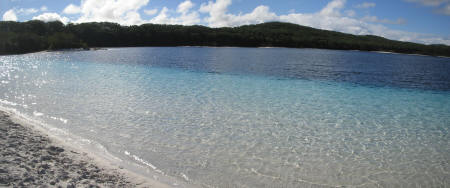
One of the highlights of Fraser Island is to visit the lakes. High up in the hills of Fraser Island there are perched lakes. Layers of sediment form an impervious (waterproof) layer in the sandy lake bed, which results in a perched lake. There are several on Fraser Island, but the best one is Lake McKenzie. We were fortunate that the rain stopped and sun came out on the morning we were there, so everything was blue. We got some nice photos and Regina went for a swim. |
Fraser Island hat wunderschöne Regenwälder, die noch viel schöner sind, wenn es regnet und das tat es auch. Ein Muss auf Fraser Island sind die Seen und vor allem Lake McKenzie. Wir hatten Glück und zwischen dem Regen hat sich wie bestellt die Sonne gezeigt. Durch den weissen Sandboden schimmert das Wasser in den schönsten Farben. Der Sand auf die Haut einmassiert gibt eine tolle Schönheitspackung. Die Haut fühlt sich danach extrem weich an. |
|
On our trips around Fraser Island we aw some great forests and trees. The tree shown below is a Scribbly Gum, deriving its name from the grub that burrows under the bark in a wriggly pattern that looks like someone has scribbled all over the tree with a pen. Fraser Island's airport is on the beach. If you look carefully on the photo you will see the plane starting take off on the sand beach that stretches 50 km north. |
Bei unseren Spaziergängen haben wir einige 'scribble gum' gesehen - kritzel bäume. Die Rinde sieht so aus, als ob jemand willkürlich darauf gekritzelt hat. Diese Kritzel sehen wirklich lustig aus und dann noch die wunderbaren knorrig-überwachsenen Astlöcher. Fraser Island und ein Flughafen, ja, wenn schon dann natürlich am Strand. Schau genau, die zwei kleinen Flugzeuge sind gerade am starten. |
|
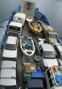
After 3 days camping on Fraser Island in heavy rain we caught the ferry back to Hervey Bay. Hervey Bay is the main town accessing Fraser Island. It was a great 3 days, but everything was wet and full of sand. It was almost a relief to get back to the mainland for a rest. The ferry back to Hervey Bay was quite full. Our Troopy is the one with the blue an orange on the roof rack in the lower right corner. |
Vom Süden auf Fraser Island haben wir uns bis zur Mitte durchgekämpft. Der Regen hat uns abgehalten weiter in den Norden zu fahren. Für die Regenwälder war der Regen ideal. Glücklicherweise mussten wir nicht zurück in den Süden sondern konnten von Kingfisher Bay im Westen der Insel die Fähre nach Hervey Bay nehmen. Die Fähre war bis auf den letzten Platz voll und der musste sein Boottrailer abhängen um wirklich Platz zu haben. |
|
Hervey Bay was quite nice. We stayed in a caravan park directly on the beach. We had dinner at the tent and then went out for some dessert. We were a little taken back by the size of the servings and the decoration. Even the people on the surrounding tables commented on the size, which is actually quite embarrassing in a restaurant. We also saw a guy playing guitar and singing live in a bar in Hervey Bay. It was a great relaxing evening. The next day the first thing we did is wash the car to try and get some of the salt and sand off. |
Wir sind wieder am Festland mit Asphalt Strassen. Die Reifen sind wieder aufgepumpt und unser Troupy ist reif für eine Schönheitspackung um wieder Sand- und Salzfrei zu sein. Bis wir den Sand von Zelt, Kleidern und Schuhen los sind dauert es noch eine Weile. Wir kochen unser Abendessen selber und verwöhnen uns mit einem schön dekorierten Kuchen - eine riesige Portion. Mit vollem Magen geniessen wir ein Live Konzert - Gitarre und Gesang - in einem irish pub. |
|
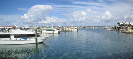
After we washed the car we headed down to the Boat Harbour of Hervey Bay. This is well worth a visit. It's very nice down there. Lot of expensive boats in the mariner and plenty of cafés and restaurants around for a snack before driving north on our continuing journey. |
Hervey Bay ist eine nette kleine Stadt. Der Hafen ist vor allem schön anzusehen. Bei einem Spaziergang oder von einem Cafe kann man exquisite Yachten bestaunen. Am Abend gibt es das ganze dann noch mit einem Sonnenuntergang. |
05 June, 2005 - 06 June, 2005 - Town of 1770
|
Because we had such a relaxing time in Hervey Bay Boat Harbour, we left a little late. So we made an unplanned but interesting stop in an historical Australien town called simply the Town of 1770. This is where Captain James Cook came ashore in 1770 when he discovered Australia. There is not really much here, but it was a nice quiet place to stop for a few days and the caravan park was quite nice. As we pulled up to the caravan park we got a flat tyre directly outside the reception. (Flat tyre No. 3). So after changing the tyre we were able to set up the tent. |
Von Hervey Bay geht weiter in den Norden. Wir bleiben in 1770. Nein, wir haben keine Zeitreise eingelegt, die Stadt heisst 1770, weil Captain James Cook hier in 1770 gelandet ist als er Australien entdeckt hat. Ausser der Tatsache, dass Cook hier gelandet ist, gibt es nichts zu sehen. Der Caravan Park ist wunderschön inmitten von Palmen mit nervigen 'brush turkeys' die versuchen ein paar Krümel von unserem Essen abzubekommen. Gerade als wir für den Zeltplatz stoppen haben wir tatsächlich noch einen Platten - schnell Reifen wechseln bevor wir das Zelt aufstellen. |
|
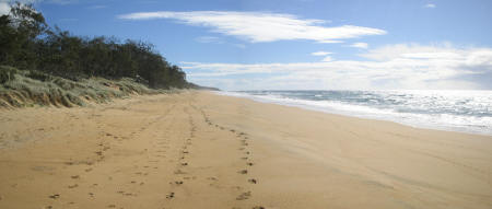
The beach was a short bush walk down a track from our camp site. The beach was long - just went on for kilometres. We are seeing many endless beaches as we get further north. You have to be careful not to lose the place where you came onto the beach when they are so long and there is only bushes and trees to orientate yourself ! |
Der Strand ist wunderschön und lädt zum Joggen ein. 1770 ist einer der südlichsten Orte von wo das Great Barrier Reef erreicht werden kann. Wir waren fest entschlossen eine Schnorcheltour zum Reef zu machen und waren recht enttäuscht, dass die Tour abgesagt wurde. Wir konnten unseren Reifen reparieren lassen und sind bereit für die Weiterfahrt. |
|
Oh ! One other nice thing that the Caravan Park had, was a Deck Bar where we drank wine on the balcony 2 nights running. And the people are really friendly. The friendly factor seems to be increasing the further north we go. It's got something to do with the warmer climate. |
Der Caravan Park - in Australien - von einem australisch-deutschen Paar geleitet und das Restaurant daneben von einem australisch-belgischen Paar. Das Restaurant war sehr schön - the Deck. Hier habe ich auch die erste 'cane toad' gesehen. Cane toads sind Kröten, die importiert wurdem um Zuckerrohrschädlinge zu fressen. Leider ohne Erfolg - jetzt sind sie eine Pest. |
Next Report : 07 June, 2005 - 11 June, 2005 - Yeppoon - Mackay - Eungella